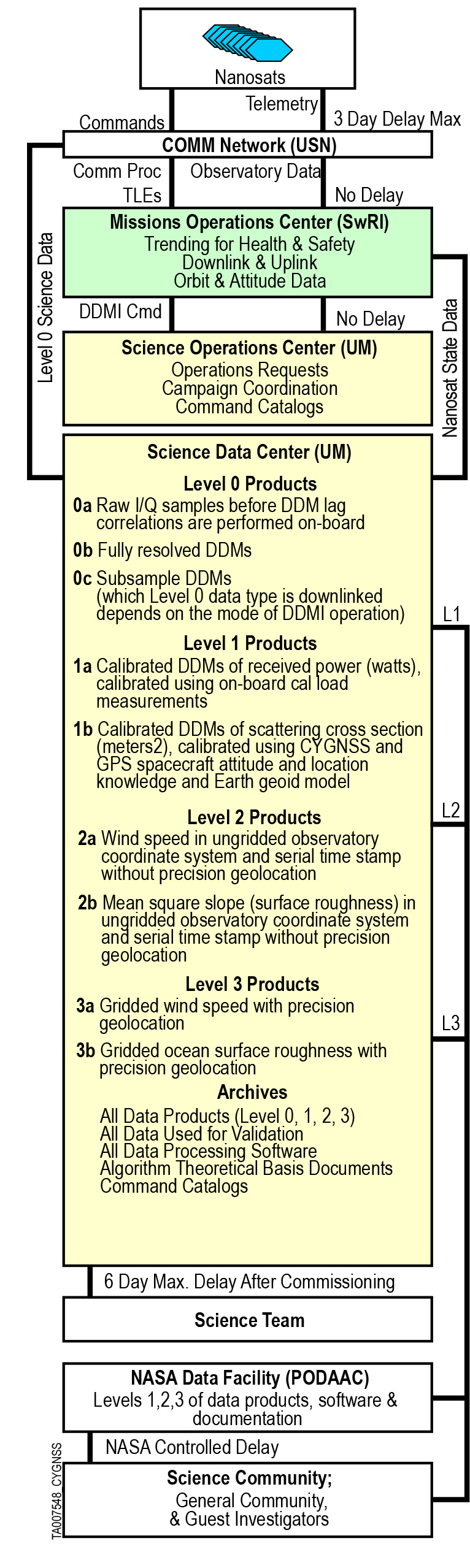
Science Data Products
Level 1 Bistatic Radar Cross Section of Earth Surface (low latency)
- Product page: https://podaac.jpl.nasa.gov/dataset/CYGNSS_L1_V3.2
- PO.DAAC Cloud data: https://cmr.earthdata.nasa.gov/virtual-directory/collections/C2832195379-POCLOUD
Level 1 Bistatic Radar Cross Section of Earth Surface (Climate Data Record)
- Product page: https://podaac.jpl.nasa.gov/dataset/CYGNSS_L1_CDR_V1.2
- PO.DAAC Cloud data: https://cmr.earthdata.nasa.gov/virtual-directory/collections/C2274919541-POCLOUD
Level 1 Bistatic Radar Cross Section of Earth Surface (Rongowai)
- Product page: https://podaac.jpl.nasa.gov/dataset/RONGOWAI_L1_SDR_V1.0
- PO.DAAC Cloud data: https://cmr.earthdata.nasa.gov/virtual-directory/collections/C2784494745-POCLOUD
Level 2 Ocean Surface Windspeed and Mean Square Slope (low latency)
- Product page: https://podaac.jpl.nasa.gov/dataset/CYGNSS_L2_V3.2
- PO.DAAC Cloud data: https://cmr.earthdata.nasa.gov/virtual-directory/collections/C2832196001-POCLOUD
Level 2 Ocean Surface Windspeed and Mean Square Slope (Climate Data Record)
- Product page: https://podaac.jpl.nasa.gov/dataset/CYGNSS_L2_CDR_V1.2
- PO.DAAC Cloud data: https://cmr.earthdata.nasa.gov/virtual-directory/collections/C2274919215-POCLOUD
Level 2 Ocean Surface Heat Flux (low latency)
- Product page: https://podaac.jpl.nasa.gov/dataset/CYGNSS_L2_SURFACE_FLUX_V2.0
- PO.DAAC Cloud data: https://cmr.earthdata.nasa.gov/virtual-directory/collections/C2247621105-POCLOUD
Level 2 Ocean Surface Heat Flux (Climate Data Record)
- Product page: https://podaac.jpl.nasa.gov/dataset/CYGNSS_L2_SURFACE_FLUX_CDR_V1.1
- PO.DAAC Cloud data: https://cmr.earthdata.nasa.gov/virtual-directory/collections/C2205121520-POCLOUD
Level 2 Ocean Surface Windspeed (NOAA)
- Product page: https://podaac.jpl.nasa.gov/dataset/CYGNSS_NOAA_L2_SWSP_25KM_V1.2
- PO.DAAC Cloud data: https://cmr.earthdata.nasa.gov/virtual-directory/collections/C2254232941-POCLOUD
Level 3 Gridded Ocean Surface Windspeed and Mean Square Slope (low latency)
- Product page: https://podaac.jpl.nasa.gov/dataset/CYGNSS_L3_V3.2
- PO.DAAC Cloud data: https://cmr.earthdata.nasa.gov/virtual-directory/collections/C2832196567-POCLOUD
Level 3 Gridded Ocean Surface Windspeed and Mean Square Slope (Climate Data Record)
- Product page: https://podaac.jpl.nasa.gov/dataset/CYGNSS_L3_CDR_V1.2
- PO.DAAC Cloud data: https://cmr.earthdata.nasa.gov/virtual-directory/collections/C2274918604-POCLOUD
Level 3 Ocean Microplastic Concentration
- Product page: https://podaac.jpl.nasa.gov/dataset/CYGNSS_L3_MICROPLASTIC_V1.0
- PO.DAAC Cloud data: https://cmr.earthdata.nasa.gov/virtual-directory/collections/C2142677420-POCLOUD
Level 3 Storm Centric Grid
- Product page: https://podaac.jpl.nasa.gov/dataset/CYGNSS_L3_S1.0
- PO.DAAC Cloud data: https://cmr.earthdata.nasa.gov/virtual-directory/collections/C2205121698-POCLOUD
Level 3 6-Hourly and Daily Soil Moisture (UCAR)
- Product page: https://podaac.jpl.nasa.gov/dataset/CYGNSS_L3_SOIL_MOISTURE_V1.0
- PO.DAAC Cloud data: https://cmr.earthdata.nasa.gov/virtual-directory/collections/C2205122332-POCLOUD
Level 3 Merged (MRG) Storm Grid
- Product page: https://podaac.jpl.nasa.gov/dataset/CYGNSS_L3_MRG_V3.2
- PO.DAAC Cloud data: https://cmr.earthdata.nasa.gov/virtual-directory/collections/C2832242310-POCLOUD
Full Delay Doppler Map
- Product page: https://podaac.jpl.nasa.gov/dataset/CYGNSS_L1_FULL_DDM_V3.0
- PO.DAAC Cloud data: https://cmr.earthdata.nasa.gov/virtual-directory/collections/C2205121474-POCLOUD
Raw Intermediate Frequency
- Product page: https://podaac.jpl.nasa.gov/dataset/CYGNSS_L1_RAW_IF
- PO.DAAC Cloud data: https://cmr.earthdata.nasa.gov/virtual-directory/collections/C2036882037-POCLOUD
- Processing software link: https://github.com/podaac/CYGNSS-Raw-IF-Code
Algorithm Theoretical Basis Documents
Level 1A DDM Calibration Algorithm Theoretical Basis Document, S. Gleason, Scott Gleason, M. Al-Khaldi, D. McKague, CYGNSS Project Document 148-0136, Rev 4, 8 December 2023. [paper]
Level 1B DDM Calibration Algorithm Theoretical Basis Document, S. Gleason, M. Al-Khaldi, D. McKague, CYGNSS Project Document 148-0137, Rev 6, 8 December 2023. [paper]
Algorithm Theoretical Basis Document (ATBD) Rongowai GNSS-R Level 1a DDM Calibration, X. Lin, Rev 2.4, 14 November 2023 [paper]
Algorithm Theoretical Basis Document (ATBD) Rongowai GNSS-R Level 1b DDM Calibration, X. Lin, Rev 2.4, 14 November 2023 [paper]
Level 2 Wind Speed Retrieval Algorithm Theoretical Basis Document, D. Pascual, M.P. Clarizia, V. Zavorotny, D. McKague, C. Ruf, CYGNSS Project Document 148-0138, Rev 8, 20 November 2023. [paper]
Level 2 Mean-Square Slope Retrieval Algorithm Theoretical Basis Document, V. Zavorotny, CYGNSS Project Document 148-0139, Rev 3, 22 September 2016. [paper]
Level 1 & 2 Trackwise Corrected Climate Data Record Algorithm Theoretical Basis Document, C. Ruf, D. Twigg, CYGNSS Project Document 148-0389, Rev 1, 26 March 2020. [paper]
Level 3 Gridded Wind Speed Algorithm Theoretical Basis Document, C. Ruf, CYGNSS Project Document 148-0319, Rev 3, 20 November 2023. [paper]
Level 3 UCAR/CU CYGNSS Soil Moisture Product User Guide, C. Chew and E. Small, 9 May 2019. [paper]
Level 3 Merged Gridded Wind Speed Algorithm Theoretical Basis Document, A. Warnock, M. Al-Khaldi, A. Russel, C. Ruf, CYGNSS Project Document 148-0412, Rev 5, 22 February 2024. [paper]
Associated Project Documents
CYGNSS Handbook (2nd Edition), ISBN 978-1-60785-549-1 [handbook]
End-to-End Simulator Technical Memo, A. O’Brien, CYGNSS Project Do148-0123_CYGNSS_E2ES_EM. [paper]