Stay current with CYGNSS mission happenings here
—————————————————-
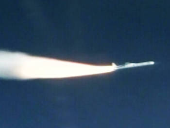
Air-launch of Pegasus XL, and stage-by-stage CYGNSS microsatellite deployment.
October 27, 2020
NASA extends CYGNSS mission through 2023
NASA recently completed its Senior Review process for the CYGNSS mission and we have been approved to continue science operations through 2023. Another Senior Review will occur at that time for another three-year extension. The constellation of eight spacecraft are all healthy and operating nominally in their orbits 524 km above the Earth. They continue to make 24/7 measurements of ocean surface winds, both globally and in tropical cyclones, which can be used to study meteorological processes and improve numerical weather forecasts. Over land, measurements of flood inundation and soil moisture are also continuously made, to be used in hydrological process studies and for disaster monitoring. We look forward to many more year of successful operation and scientific exploration.
For more details: https://news.engin.umich.edu/2020/11/hurricane-tracking-cygnss-satellite-system-gets-nasa-renewal-as-it-expands-its-reach/
April 27, 2020
CYGNSS Measurements
CYGNSS measurements are being used to help detect the breeding grounds for a major locust outbreak occurring in East Africa. Science team members at the NASA Marshall Space Flight Center, University of Alabama Huntsville, and UCAR are working with the US Agency for International Development and the United Nation Food and Agriculture Organization to develop a method for detecting the locations of the young locusts. Moist sub-surface soil conditions are identified by CYGNSS which support their eggs, and healthy vegetation is identified by MODIS NDVI which is necessary to sustain young locust development. If both are present at the same time and place, the probability of locusts being there increases and this provides advance warning for mitigation efforts to be deployed before they can fly.
For more information about this exciting new application, go here https://reliefweb.int/report/world/servir-produces-maps-support-efforts-against-locust-outbreak-eastern-africa.
—————————————————-
December 15, 2019
Happy Birthday, CYGNSS!
The eight-satellite constellation is celebrating three years on orbit!
CYGNSS Principal Investigator Prof. Chris Ruf looks at what the mission has accomplished, and where it’s going in a new blog post at NASA’s Earth Observatory blog.
“CYGNSS was launched on December 15, 2016 at 13:27:21 UTC and today marks the completion of its third year on orbit. Much has happened in that time and the future looks very promising, with all eight microsatellites healthy and operating continuously in their nominal science data-taking mode. Year 1 was spent on engineering commissioning and initial ocean wind measurements. In year 2, the ocean wind retrievals were refined and characterized and investigations of observations over land began in earnest.
“This past year has seen progress on several fronts. An important refinement to the engineering calibration has been developed. Ocean wind measurements in tropical cyclones have been successfully introduced into numerical hurricane forecast models. And the ability to image inland waterbodies with high resolution has been leveraged to demonstrate two new measurement capabilities.”
Read the full post here.
—————————————————-
October 25, 2019
A new measurement capability by CYGNSS is featured in a recent article in Remote Sensing titled “Response to Variations in River Flowrate by a Spaceborne GNSS-R River Width Estimator”. Measurements made by CYGNSS during river overpasses are used to estimate its width. The river’s associated GNSS-R width (AGW) is found to be highly correlated with in situ measurements of river flowrate. Potential applications of AGW measurements include better monitoring of stream flow and prediction of flooding on a global scale. The paper was authored by former CLaSP undergrad and current SRI research scientist April Warnock and Prof. Chris Ruf of CLaSP. The paper is available here: https://doi.org/10.3390/rs11202450
—————————————————-
June 28, 2019
A new article has been published in the Bulletin of the American Meteorological Society detailing CYGNSS performance against its Level 1 Mission Science Requirements. “In-Orbit Performance of the Constellation of CYGNSS Hurricane Satellites” presents current best estimates of CYGNSS ocean surface wind speed measurements with respect to uncertainty, dynamic range, spatial resolution, spatial and temporal sampling, and data latency.
The paper is authored by Prof. Chris Ruf, CLaSP research scientist Darren McKague, CLaSP graduate student Rajeswari Balasubramaniam and SPRL engineer Dorina Twigg at the University of Michigan, together with Shakeel Asharaf (UCLA/NASA JPL), Scott Gleason (UCAR), Timothy Lang (NASA MSFC), and Duane Waliser (NASA JPL). The paper is available here: https://journals.ametsoc.org/doi/pdf/10.1175/BAMS-D-18-0337.1
—————————————————-
June 12, 2019
Prof. Ruf was recently interviewed by Science magazine on U.S. Military changes to the signal strength of several GPS satellites, and their effect on the CYGNSS mission.
Read the full article: https://www.sciencemag.org/news/2019/06/nasa-overcomes-militarys-gps-tweaks-peer-inside-hurricanes
—————————————————-
May 10, 2019
Validated daily and 6-hourly level 3 soil moisture data products derived from CYGNSS level 1 measurements are now available for the full mission on a UCAR file server <https://data.cosmic.ucar.edu/gnss-r/soilMoisture/cygnss/level3/>.
Data descriptions, validation information, and uncertainty estimates are contained in a handbook also posted on the site. For further information, contact Dr. Clara Chew <[email protected]>.
meetingapp.cgi/Paper/351968
—————————————————-
February 11, 2019
Video and audio recordings of CYGNSS presentations given at the American Meteorological Society’s Annual Meeting in January 2019 are now available on-line for public viewing. Following are the titles and authors of the papers, and links to the presentations.
Mission Overview
NASA CYGNSS MISSION SCIENCE HIGHLIGHTS
Derek J. Posselt, JPL, Pasadena, CA; and C. S. Ruf, R. Atlas, N. L. Baker, D. Burrage, J. A. Crespo, J. T. Johnson, T. J. Lang, M. Moghaddam, E. D. Maloney, D. McKague, M. Morris, Z. Pu, E. M. Riley Dellaripa, and D. E. Waliser https://ams.confex.com/ams/2019Annual/ meetingapp.cgi/Paper/354172.
CYCLONE GLOBAL NAVIGATION SATELLITE SYSTEM (CYGNSS): STATUS OF MISSION AND SCIENCE DATA PRODUCTS
Christopher S. Ruf, Univ. of Michigan, Ann Arbor, MI; and S. Gleason, D. McKague, D. J. Posselt, and M. Moghaddam https://ams.confex.com/ams/2019Annual/ meetingapp.cgi/Paper/352478.
Data Assimilation for Tropical Cyclone Forecasting
ASSIMILATION OF CYGNSS WIND DATA FOR IMPROVING TROPICAL CONVECTION FORECASTS
Xuanli Li, Univ. of Alabama, Huntsville, AL; and T. J. Lang and J. R. Mecikalski https://ams.confex.com/ams/2019Annual/ meetingapp.cgi/Paper/350519
IMPACT OF CYGNSS OCEAN SURFACE WIND SPEEDS ON ANALYSIS AND FORECASTS OF HURRICANE HARVEY AND IRMA (2017) WITH HWRF MODEL
Zhiqiang Cui, Univ. of Utah, Salt Lake City, UT; and Z. Pu, C. Ruf, and V. Tallapragada https://ams.confex.com/ams/2019Annual/ meetingapp.cgi/Paper/351493
IMPACT OF CYGNSS DATA ASSIMILATION ON TROPICAL CYCLONE FORECASTS IN AUGUST 2017
Michael J. Mueller, CIRES and NOAA/ESRL/GSD, Boulder, CO; and B. Annane, A. C. Kren, and L. Cucurull https://ams.confex.com/ams/2019Annual/webprogram/Paper351352.html
IMPACT OF CYGNSS DATA ON TROPICAL CYCLONE ANALYSIS AND FORECASTS USING THE OPERATIONAL HWRF
Bachir Annane, Univ. of Miami and NOAA/AOML, Miami, FL; and B. D. McNoldy, S. M. Leidner, R. N. Hoffman, R. Atlas, and S. J. Majumdar https://ams.confex.com/ams/2019Annual/ meetingapp.cgi/Paper/351968
GLOBAL IMPACTS OF ASSIMILATING CYGNSS WINDS ON SURFACE WIND FIELDS USING A 2-DIMENSIONAL VARIATIONAL ANALYSIS METHOD
S. Mark Leidner, Atmospheric and Environmental Research, Norman, OK; and S. J. Majumdar, J. Hegarty, and B. D. McNoldy https://ams.confex.com/ams/2019Annual/ meetingapp.cgi/Paper/352430
ADVANCES IN WIND MEASUREMENTS AND THEIR IMPACTS ON SEVERE WEATHER FORECASTING: PROGRESS AND PROSPECTS
Zhaoxia Pu, Univ. of Utah, Salt Lake City, UT; and R. Atlas, G. D. Emmitt, and C. Velden https://ams.confex.com/ams/2019Annual/ meetingapp.cgi/Paper/351525
Other Ocean Science Applications
SURFACE HEAT FLUX ANALYSIS AND PRODUCTS FOR THE CYGNSS MISSION
Juan A. Crespo, JPL, Pasadena, CA; and D. J. Posselt https://ams.confex.com/ams/2019Annual/meetingapp.cgi/Paper/352152
CHARACTERISTICS OF DIURNAL CONVECTION AND WINDS OVER THE MARITIME CONTINENT DURING YMC WITH WRF NUMERICAL SIMULATIONS AND DATA ASSIMILATION AT A CLOUD PERMITTING SCALE
Zhaoxia Pu, Univ. of Utah, Salt Lake City, UT; and C. Zhang https://ams.confex.com/ams/2019Annual/meetingapp.cgi/Paper/353918
Terrestrial Applications
MAPPING FLOODING DURING SEVERE WEATHER EVENTS USING OBSERVATIONS FROM CYGNSS
Clara Chew, UCAR, Boulder, CO; and L. Read, J. J. Braun, D. J. Gochis, W. S. Schreiner, and S. Gleason https://ams.confex.com/ams/2019Annual/meetingapp.cgi/Paper/354935
Validation of Ocean Wind Measurements
USING IN SITU MEASUREMENTS TO VALIDATE CYGNSS WIND SPEED OBSERVATIONS
Xiaochun Wang, Univ. of California, Los Angeles, Los Angeles, CA; and Y. Hu, J. T. Johnson, Y. Yi, C. K. Shum, and D. Wang https://ams.confex.com/ams/2019Annual/meetingapp.cgi/Paper/354145
—————————————————-
December 15, 2018
Two year anniversary of CYGNSS on orbit
CYGNSS Mission Principal Investigator Professor Chris Ruf has written a new blog post at NASA’s Earth Observatory blog on the occasion of the 2-year anniversary of the satellites’ ascent to orbit.
“The constellation of eight CYGNSS microsatellites reached a milestone today, completing its second year on-orbit. The first year had focused primarily on engineering commissioning, calibration and early validation of the science data products. The second year was spent continuing to refine and improve the quality of the science data products, while also applying the measurements to a number of scientific investigations…”
Read the full post here.
—————————————————-
September 21, 2018
CYGNSS Public Science Data Release Version 2.1
Version 2.1 Science Data Records for CYGNSS are now available at the NASA PO.DAAC public data portal. This represents the second “post-provisional” release of the CYGNSS Science Data Record generated using calibrated and validated level 1 and 2 algorithms. All data users moving forward are advised to use this latest version for fundamental science and applied research activities. The Level 1 (L1) Science Data Record contains measurement of surface Normalized Bistatic Radar Cross Section. The Level 2 (L2) Science Data Record contains derived ocean surface wind speed and mean square slope (MSS). The Level 3 (L3) Science Data Record delivers hourly averaged wind speed and MSS provided on a 0.2×0.2 degree latitude by longitude equirectangular grid. Each L1, L2, and L3 file provides data covering up to a full 24-hour UTC day. The L1 data files are specific to one of the eight CYGNSS observatories. The L2 and L3 data files consist of an aggregation of data provided from all operating observatories for a given day.
Data users may now gain access to the data and learn more about the updates and improvements made from Version 2.0 to Version 2.1 by visiting the following dataset information pages:
- L1: https://podaac.jpl.nasa.gov/dataset/CYGNSS_L1_V2.1
- L2: https://podaac.jpl.nasa.gov/dataset/CYGNSS_L2_V2.1
- L3: https://podaac.jpl.nasa.gov/dataset/CYGNSS_L3_V2.1
—————————————————-
September 18, 2018
Hurricane Florence Resources – CYGNSS Ocean Surface Wind Speeds
All eight CYGNSS observatories have been continuously operating in science mode since Hurricane Florence transitioned from a tropical storm to a Cat1 hurricane on 9 Sep 2018. Examples of ocean surface winds measured during overpasses on 10 and 11 Sep are shown in the update linked below. These winds are derived from the standard (compressed DDM) data which are measured continuously. Higher resolution data-taking modes (Full DDM and Raw IF) have been commanded whenever the observatories are over Florence.
To read the full CYGNSS update from theNASA Earth Science Disaster Program, please go to: https://appliedsciences.nasa.gov/our-impact/news/hurricane-florence-resources-cygnss-ocean-surface-wind-speeds
—————————————————-
July 26, 2018
Flood detection a surprising capability of microsatellites mission
Hurricanes bring heavy rainfall and strong winds to coastal communities, a potent combination that can lead to devastating damage. In 2016 NASA launched a set of eight satellites called the Cyclone Global Navigation Satellite System, or CYGNSS, mission to gather more data on the winds in these tropical cyclones as part of an effort to increase data coverage of hurricanes and aid forecasts. As the first year of data is being evaluated, a new and unexpected capability has emerged: the ability to see through clouds and rain to flooded landscapes.
The flood maps are possible thanks to one of the innovations of the CYGNSS constellation. The microwave signal the CYGNSS satellites use to detect wind speed based on the choppiness of the ocean is actually not generated by the satellites at all. Instead the satellites use the constant and ubiquitous signals from the Global Positioning Satellite (GPS) system, which is also responsive to reflections from standing water and the amount of moisture in the soil.
To read the full news release from NASA/Goddard Space Flight Center, please go to: https://www.eurekalert.org/pub_releases/2018-07/nsfc-fda072618.php
—————————————————-
MAY 11, 2018
IEEE JSTARS journal accepts new CYGNSS team papers for special issue
The IEEE Journal of Selected Topics in Applied Earth Observations and Remote Sensing recently sent out a call for papers for a special issue titled, “Cyclone Global Navigation Satellite System (CYGNSS) Early On Orbit Performance.”
Four papers from the CYGNSS science team have been accepted for publication and can be read here. Some of the most significant results pertain to wind speed measurement performance, which has been validated to have an uncertainty of 1.4 m/s below 20 m/s and 17% above 20 m/s.
To read the four papers, please go to: https://cygnss.engin.umich.edu/publications/
—————————————————————————————————–
DEC. 20, 2017
Cyclone Global Navigation Satellite System (CYGNSS) Version 2.0 Science Data Records are now available at the NASA PO.DAAC.
Version 2.0 represents the first “post-provisional” release of the CYGNSS level 1, 2 and 3 science data products generated using calibrated processing algorithms which were trained and validated against intercomparison wind speed measurements made during the 2017 Atlantic hurricane season.
Version 2.0 supersedes the previous provisional data versions 1.1 and 1.0, and all data users moving forward are advised to use this latest version for fundamental science and applied research activities.
For more information, go to: https://podaac.jpl.nasa.gov/CYGNSS.
For detailed descriptions of the science data products, go to:
http://clasp-research.engin.umich.edu/missions/cygnss/data-products.php
—————————————————————————————————–
DEC. 15, 2017
First year anniversary of CYGNSS on orbit ..
On the anniversary of the CYGNSS launch, Principal Investigator professor Chris Ruf sums up the satellite constellation’s first year in orbit.
Here’s the latest entry on the CYGNSS NASA Earth Observatory blog:
“CYGNSS was launched into low Earth orbit on December 15, 2016 at 08:37 EST and today is its first anniversary. The mission has had a very busy first year on orbit, transitioning from an early engineering commissioning phase into the science observing phase in time for the very active 2017 Atlantic hurricane season. The mission was supported during the hurricane season by the NOAA Airborne Operations Center (AOC), which operates a fleet of P-3 “hurricane hunter” airplanes that make reconnaissance flights into tropical storms and hurricanes to observe wind speed and other weather conditions first hand. We worked closely with AOC to coordinate many of their flight campaigns with overpasses of the storms by CYGNSS…”
Read the full post…—————————————————————————————————–
SEPT. 27, 2017
First Atlantic hurricane observations by CYGNSS
Principal Investigator professor Chris Ruf talks about the first CYGNSS hurricane observations of the satellite constellation’s inaugural season.
Here’s the latest entry on the CYGNSS NASA Earth Observatory blog:
“The CYGNSS constellation has been operating in its science data-taking mode continuously since March 2017. The satellite hardware has been performing as designed while we make adjustments to the software on-board and on the ground so we are better able to operate smoothly and autonomously. We also spent much of the summer working on the relative spacing between the satellites, by adjusting their differential drag and, as a result, their relative orbital velocities…”
Read the full post…—————————————————————————————————–
AUG. 27, 2017
Earth Observatory: Flying into Hurricane Harvey
As Hurricane Harvey neared the coast of Texas, CYGNSS Principal Invesitgator professor Chris Ruf was at the NOAA Airborne Operations Center in Lakeland, FL preparing to take off with the crew of a P-3 “Hurricane Hunter” aircraft. The Hurricane Hunters regularly fly through hurricanes to help forecasters and scientists gather both operational and research data, and this mission would penetrate Harvey just before it made landfall.
Professor Ruf has written an account of the mission on the CYGNSS NASA Earth Observatory blog:
“I had the good fortune to join the crew of the NOAA P-3 “hurricane hunter” plane that flew into Harvey on 25 Aug 2017 shortly before it made landfall in Texas. We made six pairs of eyewall penetrations. The maximum surface level winds continued to grow with each successive one as we witnessed Harvey’s rapid intensification from a Cat 2 to Cat 4 hurricane. We were able to capture much of that dynamic transition, using continuous radar and radiometer remote sensing measurements plus frequent in situ measurements by dropsondes. These will be used to help calibrate and validate our measurements by CYGNSS, which have been ongoing since Harvey first started to develop earlier in the week. Following is a description of my experience that day…”
Read the full post…—————————————————————————————————–
MAR. 31, 2017
CYGNSS Satellite Constellation Enters Science Operations Phase
NASA’s Cyclone Global Navigation Satellite System (CYGNSS) — a constellation of eight microsatellites that will take detailed measurement of windspeeds inside hurricanes — successfully completed the development and on-orbit commissioning phases of its mission on March 23 and moved into the science operations phase. The spacecraft have now begun their science instrument calibration and validation and are on track to deliver the first science data in May, just in time for the start of the 2017 Atlantic hurricane season. The CYGNSS spacecraft, launched into low-inclination, low-Earth orbit over the tropics on December 15, will make frequent measurements of ocean surface winds in and near a hurricane’s inner core, an area that up until now has proven impossible to probe accurately from space. CYGNSS is able to measure the surface winds using GPS signals reflected by the ocean surface, which are able to penetrate through the intense rain in a storm’s eye wall.
Read more…—————————————————————————————————–
MAR. 10, 2017
“First Light” Science Measurements by CYGNSS Satellite
The latest update from CYGNSS mission Principal Investigator, Professor Chris Ruf.—————————————————————————————————–
NASA CYGNSS Mission Blog
This is the official NASA blog for the CYGNSS mission. Read the latest updates from Professor Chris Ruf, principal investigator, as well as other CYGNSS mission personnel.—————————————————————————————————–
JAN. 11, 2017
“CYGNSS Launch: The Human Side“
Here’s a personal account of the CYGNSS launch and the days that followed from John Noonan, who worked as a flight controller for the launch.—————————————————————————————————–
Earth Oservatory Notes from the Field
The Earth Observatory’s mission is to share with the public the images, stories, and discoveries about the environment, Earth systems, and climate that emerge from NASA research, including its satellite missions, in-the-field research, and models.
Read the CYGNSS launch dispatches from Dr. Mary Morris. Dr. Morris is a student in the University of Michigan Departent of Climate and Space Sciences and Engineering, and a member of the CYGNSS mission science team. Dr. Morris received her doctorate this past December.—————————————————————————————————–
JAN. 5, 2017
CYGNSS Hurricane Mission Measures “First Light” Science Data
NASA’s Cyclone Global Navigation Satellite System (CYGNSS) constellation of eight spacecraft made its “first light” measurements of the ocean surface on Jan. 4, 2017. Measurements were made by one of the eight spacecraft, and mission scientists plan to activate the science instruments on the other seven in the near future. Direct measurements are made of the GPS power reflected by the ocean surface, from which near-surface wind speed can be derived over tropical oceans and, in particular, inside hurricanes.
CYGNSS was launched on Dec. 15, 2016, at 8:37 a.m. EST into a low-inclination, low-Earth orbit over the tropics. The CYGNSS constellation will make frequent and accurate measurements of ocean surface winds in and near a hurricane’s inner core, including regions beneath the eyewall and intense inner rainbands that previously could not be measured from space.
Direct science measurements are displayed as a Delay Doppler Map (DDM), which shows the GPS power reflected by the ocean in the vicinity of the targeted measurement location. One such DDM is shown here, measured by constellation spacecraft FM03 on January 4, 2017, at 11:48:31 a.m. EST/15:48:31 UTC in the South Atlantic Ocean, east of Brazil.
“Our first light DDMs are direct confirmation that the CYGNSS science instrument on FM03 is operating as expected,” said Christopher Ruf, CYGNSS principal investigator at the University of Michigan’s Department of Climate and Space Sciences and Engineering in Ann Arbor. “There are still many steps ahead of us leading to reliable improvements in hurricane forecasts, but this was a critical one and it feels great to have it behind us.”
CYGNSS is the first of the missions competitively selected through NASA’ Earth Venture Program to launch into orbit. The Earth Venture Program is managed by the Earth System Science Pathfinder (ESSP) Program Office at NASA’s Langley Research Center, Hampton, Virginia. This program focuses on low-cost, science-driven missions to enhance our understanding of the current state of the complex, dynamic Earth system and to enable continual improvement in the prediction of future changes.
The CYGNSS mission is led by the University of Michigan, with the Southwest Research Institute in San Antonio, Texas, leading the engineering development and operation of the constellation. The University of Michigan Climate and Space Sciences and Engineering department leads the science investigation, and the Earth Science Division of NASA’s Science Mission Directorate oversees the mission.—————————————————————————————————–
DEC. 15, 2016, NASA RELEASE 16-119
New NASA Hurricane Tracking Mission on Track
NASA confirmed Friday morning that all eight spacecraft of its latest Earth science mission are in good shape. The Cyclone Global Navigation Satellite System (CYGNSS) will provide scientists with advanced technology to see inside tropical storms and hurricanes like never before.
CYGNSS launched into orbit at 8:37 a.m. EST Thursday aboard an Orbital ATK air-launched Pegasus XL launch vehicle. The rocket was dropped and launched from Orbital’s Stargazer L-1011 aircraft, which took off from Cape Canaveral Air Force Station in Florida, over the Atlantic Ocean, off the coast of central Florida.
“The launch of CYGNSS is a first for NASA and for the scientific community,” said Thomas Zurbuchen, associate administrator for the agency’s Science Mission Directorate in Washington. “As the first orbital mission in our Earth Venture program, CYGNSS will make unprecedented measurements in the most violent, dynamic, and important portions of tropical storms and hurricanes.”
The CYGNSS constellation will make frequent and accurate measurements of ocean surface winds in and near a hurricane’s inner core, including regions beneath the eyewall and intense inner rainbands that previously could not be measured from space. CYGNSS will do this by using both direct and reflected signals from existing GPS satellites to obtain estimates of surface wind speed over the ocean.
“CYGNSS will provide us with detailed measurements of hurricane wind speeds, an important indicator of a storm’s intensity,” said Christopher Ruf, CYGNSS principal investigator at the University of Michigan’s Department of Climate and Space Sciences and Engineering in Ann Arbor. “Ultimately, the measurements from this mission will help improve hurricane track and intensity forecasts.”
CYGNSS is the first orbital mission competitively selected by NASA’s Earth Venture program, managed by the Earth System Science Pathfinder (ESSP) Program Office at NASA’s Langley Research Center, Hampton, Virginia. This program focuses on low-cost, science-driven missions to enhance our understanding of the current state of Earth and its complex, dynamic system and enable continual improvement in the prediction of future changes.
“There is a feeling of pride and joy knowing that you have been a part of something that is much bigger than yourself and will potentially have a significant positive impact on the general public safety,” said Jim Wells, ESSP mission manager.
Southwest Research Institute in San Antonio led the development, integration and operation of the CYGNSS microsatellites. The Space Physics Research Laboratory at the University of Michigan College of Engineering leads the overall mission execution, and its Climate and Space Sciences and Engineering department leads the science investigation. The Earth Science Division of NASA’s Science Mission Directorate oversees the mission.
The NASA Launch Services Program, based at the agency’s Kennedy Space Center in Florida, was responsible for spacecraft/launch vehicle integration and launch management. Orbital ATK Corp. of Dulles, Virginia, provided the Pegasus XL launch service to NASA.