CYGNSS Mission
CYGNSS is a NASA Earth Venture mission led by the Department of Climate and Space Sciences and Engineering in the University of Michigan’s College of Engineering. It consists of eight satellites that measure surface wind speed in tropical cyclones to improve storm forecasting. The mission was conceived, designed and implemented by faculty and students in U-M Climate and Space (or CLaSP) and engineers in the Space Physics Research Laboratory at the University of Michigan working with the Southwest Research Institute, Surrey Satellite Technology Ltd., and other subcontractors. CYGNSS is helping to revolutionize the use of small satellite constellations for essential scientific purposes.
CYGNSS Launch and Early Orbit Ops
In the video, Discovery Canada put together this nice overview of the CYGNSS mission launch and early on-obit operations for their Mighty Planes series.
Latest News
January 10, 2024
CYGNSS Data Access During PO.DAAC Website Outage
The wildfires, high winds, power outages, and evacuations in the Los Angeles area have led to operational disruptions for the Physical Oceanography Distributed Active Archive Center (PO.DAAC) and its website. Users are currently unable to browse CYGNSS data through the PO.DAAC’s website. However, users are able to download data via the PO.DAAC’s Data Subscriber and Downloader Tools (https://github.com/podaac/data-subscriber). When using these tools, you will need to know the collection name of the product you want to access. You can use our “Data Products” page (https://cygnss.engin.umich.edu/data-products/) to find the collection name of each our products. It is the part of the “Product page” URL after the “/dataset/”.
For more details:
https://www.earthdata.nasa.gov/news/los-angeles-wildfires-disrupting-daac-operations-data-access
CYGNSS Team
University of Michigan Climate & Space
Principal Investigator: C. Ruf
Cal/Val Scientist: D. McKague
Budget Manager: L. Solarek
Science Operations Center: A. Russel, D. Twigg

Southwest Research Institute
Project Manager: J. Redfern
Systems Engineer: W. Wells
Science Team Leads
Weather Systems: J. Crespo (JPL)
Tropical Cyclones/ Data Assimilation: Z. Pu (U. Utah)
Soil Moisture/ Land Modeling: M. Moghaddam (USC)
Inland Waterbodies/ Inundation: C. Chew (Muon Space)
Applications: B. Roberts (NASA/MSFC)
Instrument Scientist: S. Gleason (Daaxa LLC)

NASA Program Support
Program Scientist: W. McCarty
Program Executive: J. Wicks
Mission Manager: M. Obland
NASA’s Weather Prediction Project
The Cyclone Global Navigation Satellite System (CYGNSS) aims to improve extreme weather prediction.
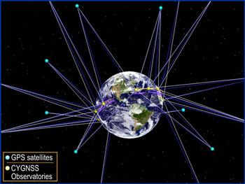
CYGNSS will use a constellation of eight small satellites carried to orbit on a single launch vehicle. In orbit, CYGNSS’s eight micro-satellite observatories will receive both direct and reflected signals from Global Positioning System (GPS) satellites. The direct signals pinpoint CYGNSS observatory positions, while the reflected signals respond to ocean surface roughness, from which wind speed is retrieved.
The mission will study the relationship between ocean surface properties, moist atmospheric thermodynamics, radiation and convective dynamics to determine how a tropical cyclone forms and whether or not it will strengthen, and if so by how much. This will advance forecasting and tracking methods.
CYGNSS data will enable scientists, for the first time, to probe key air-sea interaction processes that take place near the inner core of the storms, which are rapidly changing and play large roles in the genesis and intensification of hurricanes.
The CYGNSS mission launched on December 15, 2016!
The CYGNSS mission is comprised of 8 Low Earth Orbiting (LEO) spacecraft (S/C) that receive both direct and reflected signals from GPS satellites.
| | |