Forecasting Tropical Cyclones

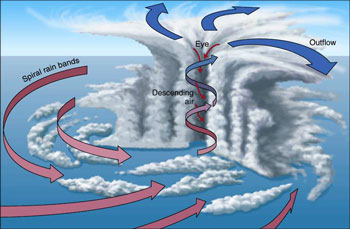
Tropical Cyclone (TC) track forecasts have improved in accuracy by ~50% since 1990, largely as a result of improved mesoscale and synoptic modeling and data assimilation. In that same period, there has been essentially no improvement in the accuracy of intensity forecasts. The fact that intensity forecasts have lagged so far behind those of the track suggests that the deficiency lies somewhere other than proper observations and modeling of the mesoscale and synoptic environment.The picture above shows the different parts of the inner core of the hurricane.
Our Hypothesis
Our hypothesis is that the principal deficiency with current TC intensity forecasts lies in inadequate observations and modeling of the storm inner core. The inadequacy in observations results from two causes:
- Much of the inner core ocean surface is obscured from conventional remote sensing instruments by intense precipitation in the eye wall and inner rain bands.
- The rapidly evolving (genesis and intensification) stages of the TC life cycle are poorly sampled in time by conventional polar orbiting, wide-swath imagers.
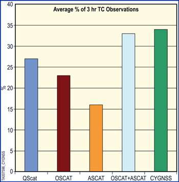
The Cyclone Global Navigation Satellite System (CYGNSS) is specifically designed to address these two limitations.The percentages of 3-hour intervals in which each scatterometer measures the TC inner core, illustrating TC sampling capability.
How CYGNSS Works
CYGNSS measures the ocean surface wind field with unprecedented temporal resolution and spatial coverage, under all precipitating conditions, and over the full dynamic range of wind speeds experienced in a TC. It does so by combining the all-weather performance of GPS-based bistatic scatterometry with the sampling properties of a dense satellite constellation.
Near-surface winds over the ocean are major contributors to and indicators of momentum and energy fluxes at the air/sea interface. Our goal, to understand the coupling between the surface winds and the moist atmosphere within a TC, is key to properly modeling and forecasting its genesis and intensification.
CYGNSS Wind Fields
CYGNSS provides surface wind fields of the TC inner core, including regions beneath the intense eye wall and rain bands that could not previously be measured from space. Mission simulation studies predict a median (mean) revisit time of 2.8 (7.2) hrs. The CYGNSS wind fields, when combined with as-frequent precipitation fields (e.g. produced by the upcoming Global Precipitation Measurement (GPM) core satellite and the current constellation of precipitation imagers), image the evolution of both the precipitation and underlying wind fields throughout the complete TC life cycle. They provide coupled observations of moist atmospheric thermodynamics and ocean surface response, and enable new insights into TC inner core dynamics and energetics.
CYGNSS Sampling Capabilities
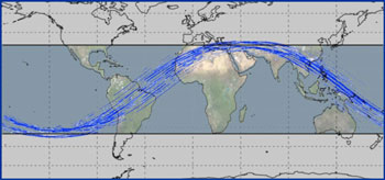
CYGNSS has a substantially higher sampling capability of TC inner core regions compared to previous ocean wind scatterometers. Currently, the highest percentage of 3-hour intervals that TC inner core regions can be sampled by a single scatterometer is about 25%. CYGNSS is capable of sampling nearly 35% of these intervals, comparable to two current scatterometers combined. Ground tracks for 90 minutes are shown above.
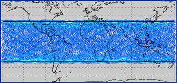
The 8 LEO S/C orbit at an inclination of 35 degrees and are each capable of measuring 4 simultaneous reflections, resulting in 32 wind measurements per second across the globe.Ground tracks for a full day are shown above.
The number of satellites, their orbit altitudes and inclinations, and the alignment of the antennas are all optimized to provide unprecedented high temporal-resolution wind field imagery of tropical cyclone (TC) genesis, intensification and decay.
The 8 LEO S/C orbit at an inclination of 35 degrees and are each capable of measuring 4 simultaneous reflections, resulting in 32 wind measurements per second across the globe.
The number of satellites, their orbit altitudes and inclinations, and the alignment of the antennas are all optimized to provide unprecedented high temporal-resolution wind field imagery of tropical cyclone (TC) genesis, intensification and decay.